
【题目】下图为南亚地区地形分布和两城市的气候图,根据图文材料和所学知识,完成下面小题。
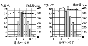
【1】与东南亚热带季风气候相比,南亚季风气候具有大陆性特征,比较气候图,指出南亚热带季风气候大陆性的主要表现
A. 有突出的热季 B. 气温的日较差更大 C. 雨季短 D. 年降水量更大
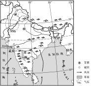
【2】图中印度半岛中部草原区的形成原因
A. 海陆热力性质差异 B. 东西两侧山脉阻挡海洋水汽
C. 赤道低压控制时间较短 D. 处于背风地带,降水少,蒸发强
【答案】
【1】 AC
【2】 BD
【解析】
本题组考查学生基础知识的灵活应用能力以及读图析图能力,涉及到的知识点主要是南亚热带季风大陆性强的表现以及印度半岛中部形成草原区的原因,需要抓图中关键信息,结合基础知识分析答题。
【1】由图可知,表现:①有突出的热季(3~5月);②雨季短,早季长(雨季比中南半岛迟一个月)或降水集中程度高;降雨变率大(雨量变化幅度大)。结合选项,AC正确,其余选项错误。
【2】草原区的形成原因:草原带的东西两侧有南北向山地,阻挡海洋气流;处于背风地带,降水少,蒸发强,水分条件只能满足高草生长。结合选项BD正确,其余选项错误。
本题组需要重视的是热带季风夏季风的成因。夏季,南亚大陆增温形成低气压,吸引气流辐合。夏季赤道低压北移,南半球的东南信风越过赤道后,向右偏转形成西南风。二者共同影响,形成西南季风。

科目:高中地理 来源: 题型:
【题目】读某日光照图,完成以下问题。
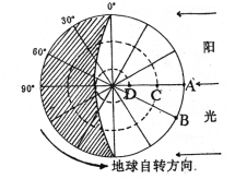
(1)此图代表的节气是_______,通常的日期是_______,此时,北京时间为_______点。
(2)图中C点地方时刻是_______点,C点太阳高度是_______。
(3)图中A点夜长_______小时,D点昼长_______小时,B点所在时区是_______。AB两点之间最近直线距离约为 _______千米。图中各点一年中,无阳光直射现象的点是_______点。
查看答案和解析>>
科目:高中地理 来源: 题型:
【题目】 墨西哥首都墨西哥城位于该国中南部高原山谷之中。人口2000多万,是美洲人口最多的都市区,集中了全国约1/2的工业、商业、服务业和银行金融机构。下图为墨西哥城及周边区域简图。
完成下列各题。
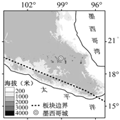
【1】不利于墨西哥城发展的自然区位条件组合正确的是
①多地质灾害 ②纬度较高
③海拔较低 ④谷地地形
A. ①③B. ②④
C. ②③D. ①④
【2】墨西哥城高度集聚的人口和产业,带来了
A. 严重的城市环境问题
B. 经济发展的强劲动力
C. 便捷高效的社会生活
D. 优美舒适的生存环境
查看答案和解析>>
科目:高中地理 来源: 题型:
【题目】阅读材料,完成下列问题。
材料一:下图是北美某区域简图。
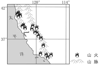
材料二:美国西部加州山区多生长有油质灌木和松树,加上特殊的气候和地形条件,山火频发。
(1)分析夏季图中沿海地区少雨多雾的原因。
(2)从气候角度评价沿海地区农业生产的自然条件。
(3)分析加州夏秋季节山火多发的原因。
(4)加州地区多低矮木质房屋,试分析其原因。
查看答案和解析>>
科目:高中地理 来源: 题型:
【题目】生态农业是美丽乡村建设的途径之一,下图为“生态农业模式示意图”。读图完成下列各题。
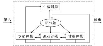
【1】下列地区中适宜推广该种农业模式的是
A. 黄土高原 B. 华南地区 C. 辽东半岛 D. 台湾南部
【2】该生态农业对建设美丽乡村所起作用是
A. 改善人口年龄结构 B. 提供优质清洁能源
C. 优化农村产业结构 D. 改善农村环境卫生
查看答案和解析>>
科目:高中地理 来源: 题型:
【题目】阅读材料,回答下列问题。
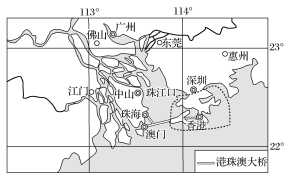
材料一 粤港澳大湾区是指由香港、澳门两个特别行政区和广东省的广州、深圳、珠海、佛山、中山、东莞、肇庆、江门、惠州等九市组成的城市群(如图所示)。

材料二 港珠澳大桥是连接香港、珠海、澳门的超大型跨海通道,全长55公里,建成后将成为世界最长的跨海大桥。港珠澳大桥沉管隧道是全球最长的公路沉管隧道和全球唯一的深埋沉管隧道,生产和安装技术有一系列创新,为世界海底隧道工程技术提供了独特的样本和宝贵的经验。如图。2018年10月23日,,正式开通;大桥于同年10月24日上午9时正式通车,驾车从香港到珠海、澳门仅需45分钟。
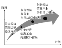
材料三 湾区经济发展形态演变一般经历港口经济、工业经济、服务经济和创新经济四个阶段(如图所示)。2016年,东京湾区服务业占比达82.3%,旧金山湾区为82.8%,纽约湾区为89.4%。而我国粤港澳大湾区九市的服务业占比为56.1%,其中香港和澳门分别为92.2%和93.4%。
材料四 下图分别为旧金山湾区地图及旧金山湾区人口数据变化情况图。
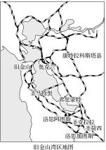

(1)简述粤港澳大湾区的区位特点。
(2)从湾区经济发展形态演变的过程看,目前粤港澳大湾区正向________阶段发展,产业发展中存在的主要问题有___________________________________________________________。
(3)旧金山湾区人口数量的结构变化,对我国大湾区发展有何启示?
(4) 港珠澳大桥中部建设成海底隧道,主要是为了( )
A.便于大型轮船通行 B.缩短通行距离 C.使大桥更加壮观 D.减小施工难度
(5)从城市体系的角度,分析粤港澳大湾区城市建设中需要注意的问题。
查看答案和解析>>
科目:高中地理 来源: 题型:
【题目】
It could be said that the age of adventure peaked with Sir Everest Shackleton the moment his ship, the Endurance, become hopelessly locked in ice on its way to Antarctica in January 1915. For ten months the 28 men aboard Shackleton’s ship waited and prayed for ice to break. When it finally did, the Endurance sank, leaving the crew homeless and adrift on a sea of ice in one of the world’s most dangerous environments.
In January 2000 a luxury ocean liner found itself similarly trapped in the cold waters off Antarctica. Argentine authorities sent off an icebreaker straight away from the nearest naval base, and in 24 hours, all 176 passengers and crew were free. The tour company’s spokesperson spun the potential disaster as a value-added reward in extreme travel. “The people on board are looking at this as sort of a great adventure,” she said.
Ever since Jon Krakauer’s book Into Thin Air made Everest a household name, the subculture of adventure has blown up like a Himalayan avalanche(雪崩) into public consciousness. Magazines promise “extreme” content, television, offers adventure programs, and the growing collective fascination with adventure has produced a flow of published accounts about the world’s greatest adventurous journey. Nowadays more and more people are interested in adventure and this mass appeal makes good business sense. Today the only thing blocking a would-be adventurer’s passage to Antarctica is the cost---- which typically runs well over $10,000.
Despite very different implications, adventure was just as popular in Shackleton’s time. He has little trouble filling the Endurance----5,000 men are said to have responded to his recruitment(招募) notice: “Men wanted for risky journey. Small wages. Bitter cold. Long months of complete darkness. Constant danger. Safe return doubtful.”
After five months drifting on ice, the crew were forced to take to their lifeboats to Elephant Island. Reaching the wasteland, Shackleton went on with one lifeboat and five of his best men 1,300 kilometers across the bone-chilly Scotia Sea to South Georgia Island. Shivering with cold, dressed in rags, Shackleton marched into a whaling station and set about organizing a rescue expedition to Elephant Island. Almost two years after becoming shipwrecked on ice, Shackleton picked up his crew. “Not a life lost, and we have been through hell,” he remarked earnestly.
【1】We can learn from the first sentence of this passage that _______.
A. the age of adventure began with the ship Endurance trapped in ice
B. Shackleton’s adventure marked the highest point of pure exploration
C. the age of adventure ended with the ship Endurance trapped in ice
D. Shackleton’s adventure predicted that the golden age of exploration was approaching
【2】The word “spun” in the second paragraph can be replaced by “_______”.
A. summed up B. judged C. boasted about D. referred to
【3】Since Jon Krakauer’s book was published _______.
A. the media have got interested in the topic of adventure
B. the costs of extreme travel have gone up
C. Everest has got its name known to Europe
D. people have got fascinated by Himalayan avalanches
【4】The adventure in Shackleton’s time has different implications from today’s in that _______.
A. Shackleton’s adventure lasted longer then any other adventure nowadays
B. no one was missing during Shackleton’s adventure
C. Shackleton’s adventure was entirely for the sake of adventure
D. Shackleton enrolled volunteers more easily
查看答案和解析>>
科目:高中地理 来源: 题型:
【题目】阅读材料,完成下列问题。
材料一:色林错流域位于青藏高原中部,面积45530km2,是西藏最大的内陆湖水系。流域内有大小湖泊 20余个,众多的河流和湖泊相互串通,组成一个封闭的内陆湖泊群。
材料二:左图为色林错流域局部位置示意图,右图为1990-2010年色林错湖泊面积的变化示意图。


(1)简析该区域夏季太阳辐射强,气温却很低的主要原因。
(2)说出色林错湖底A、B两地坡度的差异,并简述该湖泊的水文特征。
(3)说出1990-2010年色林错湖泊的变化特点,并简析其原因。
(4)简述全球变暖对该区域自然环境的不利影响。
查看答案和解析>>
科目:高中地理 来源: 题型:
【题目】现代的岛屿生物地理理论认为,物种数量由“新物种”的迁入和“原有物种”的消亡之间的动态变化所决定,是一种动态平衡的结果。读图完成下列各题。
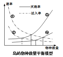
【1】图中①②③④依次是( )
A. 近陆远陆大岛小岛B. 远陆近陆大岛小岛
C. 近陆远陆小岛大岛D. 远陆近陆小岛大岛
【2】人类活动强烈影响岛屿的生物多样性。根据岛屿生物地理理论,下列对岛屿的开发符合可持续发展的是( )
A. 崇明岛距离大陆近,可以加大其湿地资源的开发力度
B. 台湾岛大于海南岛,开发规模可以大于海南岛的规模
C. 格陵兰岛为世界最大岛屿,人类开发对物种影响最小
D. 钓鱼岛面积小,应适度控制其周围海域油气开发力度
查看答案和解析>>
湖北省互联网违法和不良信息举报平台 | 网上有害信息举报专区 | 电信诈骗举报专区 | 涉历史虚无主义有害信息举报专区 | 涉企侵权举报专区
违法和不良信息举报电话:027-86699610 举报邮箱:58377363@163.com